|
Categories
|
Level 1
(50 - 59%) |
Level 2
(60 - 69%) |
Level 3
(70 - 79%) |
Level 4
(80 - 100%) |
|
Knowledge and
Understanding.
Map colours and
labels are accurately portrayed.
|
Few colours are
appropriate for features.
Few label features
are accurately portrayed.
|
Some colours are
appropriate for features.
Some label features
are accurately portrayed.
|
Many colours are
appropriate for features.
Many label features
are accurately portrayed.
|
Most colours are
appropriate for features.
Most label features
are accurately portrayed.
|
|
Thinking.
The written
component of the project fully develops an overall picture of the student's
country.
|
The overall picture of the student's
country is limited in its development.
|
The overall picture of the student's
country shows some development.
|
The overall picture of the student's
country is considerably developed.
|
The overall picture of the student's
country is highly developed.
|
|
Communication.
The map is properly
constructed.
|
Few features are
coloured in.
Few straight lines
are ruler drawn.
Legend contains few
relevant symbols.
|
Some features are
coloured in.
Some straight lines
are ruler drawn.
Legend contains
some relevant symbols.
|
Many features are
coloured in.
Many straight lines
are ruler drawn.
Legend contains
many relevant symbols.
|
Most features are
coloured in.
Most straight lines
are ruler drawn.
Legend contains
most relevant symbols.
|
|
Application.
|
Few references are
accurate.
|
Some references are
accurate.
|
Many references are accurate.
|
Most references are accurate.
|

Tuesday, February 25, 2014
Mapping Rubric


Monday, February 24, 2014
Wordle Assignment
Most Destructive Hurricanes on Record
Deadliest Hurricanes on Record
Worst Tornadoes in History:
Deadliest Tornadoes in US History
Wordle Software is linked here:
Wordle
Wednesday, February 12, 2014


Sunday, February 2, 2014


Population Density
Population Density Map
World Density
Interactive World Density
World Density II
Patterns in Human Settlement
Human Patterns
Patterns in Human Settlement II
Human Patterns II
Interesting Visual Map of Planets

World Density
Interactive World Density
World Density II
Patterns in Human Settlement
Human Patterns
Patterns in Human Settlement II
Human Patterns II
Interesting Visual Map of Planets
Fujita Scale
Don't get KICKED out of Class!!! Stay and play on this interactive website detailing the Fujita Scale:
Fujita Scale

Complete the following online quiz:
Quiz
Fujita Scale
Complete the following online quiz:
Quiz

Renewable Vs Non-Renewable
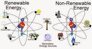
Watch the Following Video: 18 minutes
Learn 360: The Earth is Hurting
Username: ocsbstudent
Password: ocsb360
Complete the following Online Quiz:
Renewable Vs. Non-Renewable
Layers of the Earth Interactive Maps
Layers of the Earth Interactive

Try not to miss anything in the above Interactive Website. ( Like the Boxing Referee!)

Try not to miss anything in the above Interactive Website. ( Like the Boxing Referee!)
Subscribe to:
Comments (Atom)